| |
| Wayne McCrory, Bärbiologe der Valhalla Wilderness Society, weist in zwei umfassenden Studien auf die Gefährdung der Spirit-Bären auf Gribbell Island hin, sowohl durch die Folgen früherer Kahlschläge dort als auch durch die Gefahren einer drohenden Ölpest in den Gewässern um Gribbell Island, falls das Northern Gateway Pipeline-Projekt realisiert werden sollte. Der Bau der Ölpipeline von den Teersande-Abbaugebieten in Alberta nach Kitimat würde es nach sich ziehen, dass jedes Jahr bis zu 220 Öltanker durch den engen Douglas Channel unweit von Gribbell Island navigieren müssten, um das Öl abtransportieren zu können. Eine Ölpest, verursacht durch einen Tankerunfall, erscheint in diesen gefährlichen Gewässern nahezu unvermeidlich. Es ist weniger die Frage, ob sich eine solche Ölpest ereignen würde, sondern wann. Längst gibt es erschreckende Wahrscheinlichkeitsberechnungen für eine Ölpest auf diesem stürmischen und schwierig zu navigierenden Seeweg. Wayne McCrory geht in einer seiner Studien vor allem der Frage nach, welchen Gefahren die Spirit-Bären auf Gribbell Island bei einer Ölpest ausgesetzt wären. Sein 38-seitiger Bericht mit dem Titel „Spirit Bears Under Siege. A Review of the Threats of an Oil Tanker Spill from the Proposed Northern Gateway-Enbridge Project on Gribbell Island – Mother Island of the White Bear (Ursus americanus kermodei)“ ist jetzt online verfügbar auf der Website der Valhalla Wilderness Society (http://www.vws.org –> A Review of the Threat of an Oil Tanker Spill). Nachfolgend finden Sie eine Zusammenfassung wesentlicher Ergebnisse und Schlussfolgerungen des Berichts (Executive Summary): |
| |
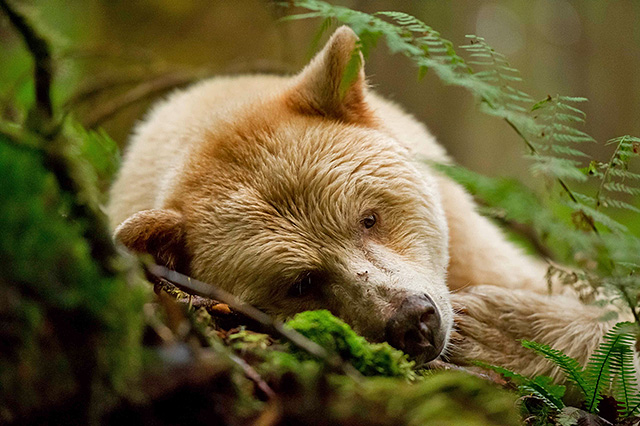 |
| Ruhender Spirit-Bär im Küstenregenwald |
© Klaus Pommerenke |
|
| |
| „The proposed Enbridge Northern Gateway Pipeline (ENGP) will pass through a significant portion of the putative range of the geographic race of the spirit or Kermode bear (Ursus americanus kermodei) between Hazelton and Kitimat, BC. About one in ten Kermode bears have a white coat, the rest are black. The proposed Enbridge tanker route from the terminal at Kitimat to the outer sea will pass through narrow and convoluted marine passageways that border islands of great evolutionary significance and variation of the genetic pool of the Kermode bear. |
| Nowhere else on the BC coast is evolutionary biology better represented than the different genetic occurrences of the white bear allele on these different Kermode islands and adjacent mainland, with particular emphasis on the high number of white bears on Gribbell Island. Genetic studies show that small Gribbell Island, some 20,690 hectares, has the highest incidence of white versus black Kermodes of any known area on the coast, with over 40 % of its small isolated population of 100 – 150 Kermode bears being all-white. Conservation biologists believe Gribbell Island to be the „mother island“ of the white bear, and the location where the gene for white-coated bears likely evolved. For these reasons, the central coast of British Columbia archipelago through which Enbridge’s oil tankers will pass is part of a region known as „Canada’s Galapagos“. Gribbell borders one of the main proposed tanker routes as well as the high-risk collision area in Wright Sound. |
| |
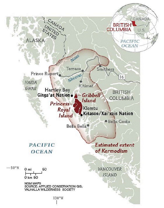 |
| Das Verbreitungsgebiet der Kermode-Bären (Ursus americanus kermodei), einer Schwarzbären-Unterart, bei der es zum Auftreten der weißen Fellfarbe kommt, den Spirit-Bären |
|
© Wayne McCrory Wildlife Services Ltd., Valhalla Wilderness Society |
|
| |
| Besides the unique Kermode bear, there are other reasons the BC central and north coast archipelago is referred to as Canada’s Galapagos. For example, there are other genetically distinct races of black bears in the region, such as the one that occurs on Haida Gwaii (Queen Charlotte Islands) to the west. This distinct subspecies has no white bears. To add to the evolutionary significance of this region, the central coast has a unique subspecies of the grey wolf. All of this is only part of the story of the unique island biodiversity of the Great Bear Rainforest through which will pass annually 220 large Enbridge-related tanker trips laden with generous volumes of bitumen. |
| Although there are serious concerns regarding the threats to Kermode bears and their main food resource, salmon, of a pipeline rupture or tanker spill throughout much of their known central coast range, due to limited time and resources, it was not the intent of this report to examine the full extent of potential environmental damage that could occur to Kermode bear populations and their food resources where the pipeline and tankers cross their habitats, but rather to do an environmental impact assessment (EIA) using Gribbell Island as the focal area. Here we have the most available habitat and genetic inventory and which we believe represents the most vulnerable and genetically unique subpopulation of the Kermode bear subspecies. |
| The study approach included a partial review of the Enbridge Northern Gateway Project (ENGP) Environmental Social Assessment (ESA) report (2010) and status reports by the Exxon Valdez Oil Spill Trustee Council (EVOSTC). The scientific literature was reviewed for effects of hydrocarbons on bears. Interviews were conducted with four northern bear biologists familiar with oil spills and effects on bears. A status report summarizing cumulative effects and conservation concerns on the Kermode bears of Gribbell Island provided the main baseline for this review of the impacts of an potential oil spill from the Enbridge project. The status report outlined that most if not all of the Kermode bears on Gribbell Island make important use of the marine foreshore for feeding on marine invertebrates and other foods and for travel. Up to 10 white bears have been observed in one day feeding and travelling in the marine intertidal shoreline of Gribbell Island, including small cubs. |
| |
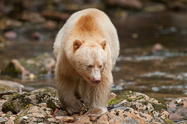 |
| Spirit-Bär an einem Lachsfluss im Küstenregenwald |
© Klaus Pommerenke |
|
| |
| Using the best information possible, my professional review concluded that a major oil spill from a tanker carrying Enbridge bitumen along the BC inside marine channels will have significant, cumulative, adverse, and immitigable impacts at the individual-level, population level, and genetic-make-up level of the Kermode bears of Gribbell Island. This is primarily because of the likelihood that all of the estimated 100 – 150 Kermode bears on Gribbell Island would come into direct and fairly lengthy and toxic contact with stranded oil on the seashore during the active bear season. Kermode bears here would also ingest toxic quantities of oil through feeding on contaminated fish, seabirds, and marine mammals killed by the spill, and also be affected metabolically from feeding on contaminated spawning salmon and marine invertebrates for which these bears are seasonally reliant. |
| Studies on Alaskan brown (grizzly) bears suggest that bears exposed to minor oil contamination may not sustain long-term effects, but the same studies as well as several on polar bears indicate that bears exposed to more intensive contamination would suffer physically and physiologically for a variety of reasons, including a reduction of the thermoregulation mechanisms through loss of fur (alopecia) caused by oiling, kidney failure from ingestion of too much oil, disturbances to red blood cell production (erythropoietic dysfunction), and other toxicological impacts; often leading to mortality. There is every reason to conclude that Kermode bears on Gribbell Island will suffer the same mortality effects from extensive oil exposure as documented for Alaskan brown (grizzly) bears and for polar bears. Younger Kermode bears that use the marine intertidal would likely be the first to suffer serious toxic effects and mortality. An unknown effect would be bears entering hibernation with oil-caused fur loss and oil-contaminated body tissue, but it is likely going to cause den mortality. Many Kermode bears are thus expected to die. |
| Further, oil-caused reductions in marine food resources (salmon, mussels, barnacles, etc.) will add to the impact and population stress. Such damage will likely be long term. Some 20 years after the Exxon Valdez oil spill, the marine ecosystem is still suffering substantial and persistent contamination of mussel beds. |
| This oil-spill-generated population stress and reduction will also be magnified by the known vulnerability of small island populations to extinction; in this case, the isolated or semi isolated nature of 100 – 150 Kermode bears on Gribbell Island, combined with cumulative effects on food resources already occurring from habitat reductions from logging and marine over-fishing of the salmon resource. The fact that one-third of the island is non-vegetated rock and that it lacks the normal productive estuarine marine habitats found elsewhere in more productive Kermode islands, adds to the population stress. |
| In conclusion, based on all of the evidence reviewed, there is every reason to believe that Kermode bears on Gribbell Island will cumulatively suffer high mortality and a severe population decline from a major oil spill within perhaps 100 – 200 km or more of the island. This rare and unique gene pool will also be seriously affected. Studies show that white Kermodes eat more salmon and marine invertebrates than black Kermodes. A major oil spill will thus have the likelihood of causing a higher rate of mortality to white Kermodes, significantly altering the gene pool over time, as the population declines. |
| The net result from a Kermode bear population decline caused by a major Enbridge oil spill on Gribbell will be to push the bears over the „extinction threshold“ as identified by Bascompte and Sole (1996), from which the population may never recover, either in numbers or genetic make-up. And this is just one small focal area of a much larger impact zone, not just for Kermode bears but the whole unique marine-terrestrial ecosystem on British Columbia’s central coast. |
| In contrast to my findings, while acknowledging that toxic effects from an Enbridge related oil spill scenario would occur to bears and other mammals, the Enbridge ESA (2010) concluded that only a limited number of coastal grizzly and Kermode bears would be affected. The Enbridge study provided no systematic analysis as evidence to support such a conclusion for such a high risk project, with so much biologically at stake. As near as I could determine, none of the scientific literature on the effects of hydrocarbons on bears that I have cited was referenced in the ENGP ESA (2010). The northern bear biologists I interviewed for my study, who are well familiar with the effects of oil contamination on Alaskan brown (grizzly) bears and/or polar bears, said they had never been approached by any Enbridge-commissioned scientist working on the ENGP ESA. These are glaring technical omissions for such a high risk and high profile project. The end result of this obvious lack of scientific rigour in the Enbridge ESA study, is, in my professional opinion, speculative, misleading and erroneous. |
| The ENGP ESA is accurate in that it acknowledges that past oil spills indicate the potential for large effects on only some aspects of the biophysical environment on the BC Central Coast. They then claim that the 1989 EVOS lasted only a generation or more for some organisms. To support this contention, they cite a study (Harwell and Gentile 2006) that these effects have not damaged the structure, function, and overall health of regional populations. There is now important new research by Landis (2007), EVOSTC (2009, 2010), and other independent research that demonstrates this conclusion about no long-term population effects is seriously flawed. This is not cited by the Enbridge ESA. |
| In my professional opinion, there are other glaring technical deficiencies and omissions in Enbridge’s 2010 ESA. Data from the Exxon Valdez oil spill studies suggests that the Enbridge review underestimates the areal extent, severity, and longevity of the oiling of the BC central coast from a spill from a large tanker spill carrying their oil. Also seriously lacking are detailed and accurate maps of oil spill trajectory models. |
| It is my recommendation that the ENGP ESA (2010) conclusions on the effects of the project on coastal bears not be accepted by the Joint Review Panel. |
| It is also my recommendation that the project not be approved at all by the Joint Review Panel or any provincial, federal or First Nation governmental body. The risks are simply too high. Again, nowhere else on the BC coast is evolutionary biology better represented that the different genetic occurrences of the white bear allele on the different Kermode islands and adjacent mainland, with particular emphasis on the high number of white bears on Gribbell Island. How could the loss from an oil tanker spill of such a rare and unique bear population, which took eons to create, ever be mitigated?“ |
| |
| Die zweite Studie von Wayne McCrory mit dem Titel „Spirit Bears Under Siege. The case for the protection of Gribbell Island – mother island of the White Bear“ geht auf die genetische Besonderheit der Spirit-Bären ein, auf die Häufigkeit des Vorkommens der weißen Fellfarbe bei dieser Unterart der Schwarzbären, den Kermode-Bären und auf die relative Isolation der weißen Spirit-Bären auf Gribbell Island. In Anlehnung der Isolation der Galapagos Inseln bezeichnet Wayne McCrory Gribbell Island als „Kanadas Galapagos“ mit hoher evolutionsbiologischer Bedeutung. Auch dieser 58-seitige Bericht ist jetzt online verfügbar auf der Website der Valhalla Wilderness Society unter http://www.vws.org –> The Case for the Protection of Gribbell Island. Der Bericht untersucht die negativen Einflüsse früherer Kahlschläge und des Baus von Forststraßen auf Gribbell Island auf die Lachspopulationen in den beiden einzigen Lachsflüssen, die für die dort lebenden Bären als Nahrungsquelle im Herbst größte Bedeutung haben. Der Rückgang der Lachspopulationen durch andere Faktoren (kommerzielle Fischerei, Veränderung der Ozeanbedingungen durch den Klimawandel) wird erörtert, auch mögliche Einflüsse des Bärbeobachtungs-Tourismus auf die Bären werden diskutiert. Das Gefährdungspotential für die Spirit-Bären durch kumulierende Negativeffekte wird eingeschätzt, wobei Satellitenbilder herangezogen werden, die das Ausmaß der früheren Kahlschläge dokumentieren. |
| |
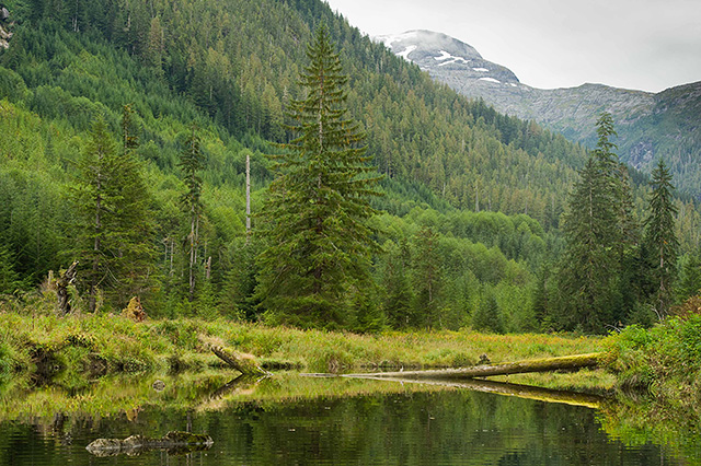 |
| Diese Fläche am Riordan River auf Gribbell Island wurde vor ca. 25 Jahren bis auf einzelne Bäume kahl geschlagen, leider bis an die Flussufer heran. Aufnahme vom Herbst 2012 |
© Klaus Pommerenke |
|
| |
| Vegetationskarten zeigen, wo auf Gribbell Island Gebiete sind, in denen die Bären gute Nahrungsgrundlagen finden (Gebiete z. B. mit guter Beerenvegetation, mit Gräsern und Seggen, mit dem Vorkommen des pazifischen Wild- oder Holzapfels). Bereits jetzt wurden 7 % des ökologisch bedeutsamen produktiven Urwaldes mit alten Bäumen durch frühere Kahlschläge vernichtet. Dies erscheint zwar relativ wenig, jedoch muss berücksichtigt werden, dass nahezu vegetationslose Fels- und Bergregionen fast 1/3 der Fläche von Gribbell Island ausmachen. Eine weitere Karte zeigt die Gebiete, in denen die Bären bevorzugt ihre Winterhöhlen anlegen. Dies sind Gebiete mit 300 – 500 Jahre alten Bäumen, die hohl sind oder mächtige Wurzelstöcken haben, unter denen die Bären sich ihr Winterlager graben können. Diese Gebiete finden sich in tieferen bis mittleren Höhenlagen. In diesen Gebieten liegen auch die Wintereinstände der Schwarzwedelhirsche. Wenn keine frischen Seggen, noch keine Beeren oder im Herbst die ersten Lachse verfügbar sind, sind vor allem die Kitze der Schwarzwedelhirsche eine bevorzugte Beute der Bären. Der Schutz der Wintereinstände der Schwarzwedelhirsche vor weiterem Holzeinschlag dient somit auch dem Überleben der Bärenpopulation auf Gribbell Island. |
| |
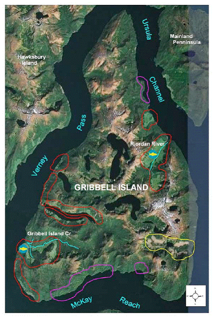 |
| Satelliten-Aufnahme von Gribbell Island. Rot, Lila und Gelb markiert sind Kahlschlagsflächen. Die Kahlschläge am Riordan River und Gribbell Island Creek sind ca. 25 Jahre alt, die im Südosten stammen von 2003. 2004 erfolgte Holzeinschlag mit Hilfe von Helikoptern im Osten der Insel. Die Kahlschläge am Riordan River und Gribbell Island Creek sind verantwortlich für den erhöhten Sedimenteintrag und somit auch für den Rückgang der Lachspopulationen in diesen Flüssen |
© Wayne McCrory Wildlife Services Ltd. & Baden Cross,
Applied Conservation GIS |
| |
| In der Zusammenfassung der Studie heißt es: |
| „In summary, of the five man-caused influences we examined, early fur trapping for white bear pelts and early 20th century hide hunting/collection of bears with a white pelage for museum specimens have likely reduced the white bear gene in the small distinct Gribbell Island Kermode bear population. Forestry practices (clearcut logging and associated roading) combined with mismanagement of small salmon stocks in the commercial fisheries has had the greatest influence on reducing overall food productivity for Kermode bears on Gribbell Island with effects magnified by the generally poor natural productivity, the small size of the island and the small insular bear population. The diminishing salmon runs may already be having a negative effect on the ratio of white versus black Kermodes since white bears feed more on salmon. Climate change is expected to exacerbate this drop in productivity. Effects of bear-viewing tourism and research have had little or no effect. Although being examined in an adjunct chapter to this report that is still being completed, the proposed Enbridge oil tanker traffic in the adjacent marine channels and the risk of a spill is considered a new and very serious threat to this genetically unique and vulnerable Kermode population. |
| Our review underscores the vulnerability and threats to small island populations of large mammals and a rare evolutionary genotype of bear as found on Gribbell Island from manmade changes that may be masked by wrong assumptions, lack of adequate baseline research, and wrong management prescriptions that ignore cumulative effects. |
| |
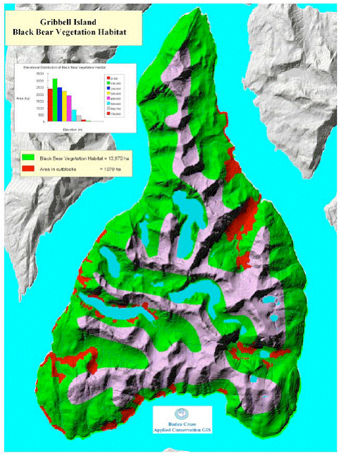 |
| Vegetationskarte von Gribbell Island. Grün: Vegetation, die den Bären eine gute Nahrungsgrundlage bietet; Lila: Fels- und Berggebiete nahezu ohne Vegetation; Rot: Kahlschlagsgebiete; Blau: Inlands-Seen |
© Wayne McCrory Wildlife Services Ltd. & Baden Cross,
Applied Conservation GIS |
| |
| The limited and declining salmon resource on Gribbell Island underscores the need to preserve as much of the surviving native forests and productive vegetation habitat as possible so bears still have viable alternative berry foods in years of continued poor salmon numbers, or while salmon stocks, hopefully, are recovering. We agree with Darimont et al. (2010) that limitations must be imposed on exploitation of small salmon runs in areas and during periods through which salmon bound for important terrestrial areas can migrate. Gribbell Island is one such area. |
| While further studies are needed to understand the evolution of the Kermode bear and ist genetic structure and population needs before we cross critical thresholds of extinction and cause changes that are irreversible, it is urgent that we preserve what we have based on what we already know, since it is not ours to destroy or alter. |
| To these ends, we are recommending to the Gitga’at First Nation government and the provincial government that no further industrial exploitation be allowed on Gribbell Island and that it be recognized as an part of an Evolutionary Significant Unit and be fully protected as a provincial conservancy, perhaps with a respected Gitga’at name as a Tribal Park. … It is our hope that protecting Gribbell Island will continue to bring international recognition to what is truly part of Canada’s Galapagos and, in turn, help turn the tide against the federal government’s endorsement of Enbridge and the oil tankers.“ |
| |
 |
| Spirit-Bär beim Lachsfang |
© Klaus Pommerenke |
|
| |
 zurück zurück |